
Guided iPhone capture
A guided SiteScan workflow on an iPhone Pro records open trenches, house connections, objects, and technical rooms without dedicated scanning hardware.

sizeless is a digital-twin and automated documentation workflow for civil engineering and utility construction. Its SiteScan app turns guided iPhone Pro video captures of trenches and house connections into 3D point clouds, DWG/DXF as-built plans, and GIS-oriented pipe-route models.
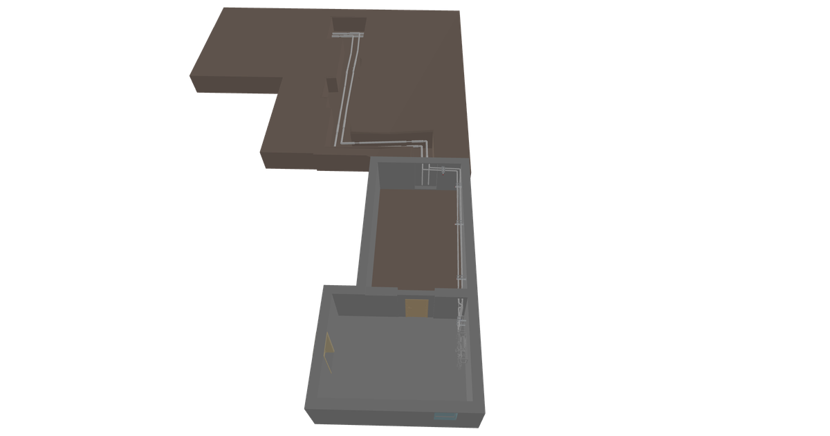
sizeless is a digital-twin and automated documentation workflow for civil engineering and utility construction. Its SiteScan app guides an existing project team through recording open trenches and house connections with an iPhone Pro, then converts the video into structured 3D and CAD documentation.
The service is positioned for road and utility construction, district heating, and house connections. Its outputs include a high-resolution 3D point cloud, DWG/DXF as-built plans, and a 3D pipe-route model for GIS workflows, allowing teams to document installations before backfilling and use the resulting records for review, billing, planning, and maintenance.
A guided SiteScan workflow on an iPhone Pro records open trenches, house connections, objects, and technical rooms without dedicated scanning hardware.
Algorithms developed at ETH Zurich generate a high-resolution, centimeter-accurate 3D point cloud from the recorded scene.
The service creates 2D as-built documentation in DWG and DXF, helping teams identify pipes and couplings and simplify dimensioning.
A digital twin represents the pipe route, including house entries, and can be connected to modern GIS systems for planning and maintenance.
Documentation includes foreign utilities and house entries, providing a 3D record before the trench is backfilled.
The workflow is intended to let existing crews document connections independently, reducing reliance on separate surveying appointments.
Record an open trench immediately after installation, generate as-built plans, and retain a 3D record before the excavation is backfilled.
Document service connections and house entries as part of the installation workflow, including conditions in basement areas where GPS is unavailable.
Use the resulting DWG/DXF plans and pipe-route model to support connection billing, review dimensions, and identify pipes or couplings without arranging a separate measurement visit.
Capture district-heating and other utility corridors with foreign utilities included in the 3D record, creating source material for GIS-based planning and later maintenance.
Let existing installation crews perform guided field capture with a smartphone when project volume makes repeated manual sketches or separate surveying appointments impractical.
The documented workflow starts with a guided video capture in the SiteScan app on an iPhone Pro. The existing project team can perform the capture at the open trench, without additional scanning hardware or a separate surveying appointment.
The service processes the smartphone video into a high-resolution 3D point cloud and produces 2D CAD as-built plans in DWG/DXF. It also provides a 3D digital twin of the pipe route, including house entries, for GIS workflows.
The site states that the workflow can be used in basement areas without GPS and can document foreign utilities and house entries. The published material does not define all environmental or project limitations.
The documented process is designed for existing project teams to capture house connections independently with a smartphone. The site does not publish detailed team permissions, onboarding steps, or account requirements.
No pricing details are published on the available pricing page. The website instead provides a demo request form for interested organizations.

DeepMotion is a web-based AI motion capture and 3D animation platform with Animate 3D for video-to-animation and SayMotion for text-to-animation. It helps creators and teams generate motion in a browser and export results in common production formats.
Atlasly is an AI site analysis and feasibility tool for architects, real estate developers, and urban planners. It helps users assess planning constraints, walkability, and urban context in a web app or through MCP-connected AI assistants.

anyCreature is a GitHub project that turns a short text order into a game-ready 3D creature. It compiles a single JSON spec into a skinned GLB with animation, vertex colour, ambient occlusion baking, and an offline showroom viewer.

模袋云 est un logiciel de modélisation de villas en ligne à faible seuil d'entrée.

Vizcom est une plateforme de design IA pour transformer des croquis en rendus 3D photoréalistes, avec itération, visualisation contextuelle et animation.

Amara is an AI-powered 3D creation tool focused on mesh generation and plugin-based actions. It offers a free entry point, tiered plans for individuals and teams, and staged early access.